
Product introduction:
Intelligent Water Conservancy Integrated Management Software (hereinafter referred to as SW1000) is independently developed by HopeVision. It is a comprehensive security protection platform that integrates user management, video surveillance, 2D and 3D electronic maps, target recognition for people, vehicles and ships, and hydrological environment perception and early warning. Based on actual business needs, the system combines hydrological data perception technology, audio and video technology, deep learning technology, network communication technology and software platform technology to build a system platform software based on optoelectronic equipment. The system has the functions of automatic detection of hidden dangers, identification of hidden dangers, precise location of hidden dangers, reporting of hidden dangers information, and tracking and processing of hidden dangers.
The system can be applied to the monitoring and management of rivers, lakes, reservoirs, water resources and water conservancy projects. All-in-one solution. Through the application of image intelligent analysis technology, the behavior of floating objects on the water surface, illegal fishing, fishing, sand mining and swimming can be effectively identified, and an intelligent unattended application system can be provided in combination with the zoning and classification management strategies of the water coastline. The system adopts the design concept of micro-service and modularization. Through the integration of various functions, the minimum granularity of each service module in the system is realized to ensure that the built service module has the characteristics of high cohesion and low coupling.
The system can fully support Hepu's photoelectric pan-tilt and photoelectric turntable devices, which usually have dual channels of visible light and thermal imaging, and have the function of returning the azimuth field of view angle.
Features:
1) Multi-level management and control: support central cluster deployment and use in multiple places; support multi-level joint prevention and control of provinces, cities, and counties; support strategic scheduling such as coordination, exclusiveness, and preemption of optoelectronic equipment at all levels;
2) Multi-mode unattended: support unattended in warning zone mode and unattended in photoelectric automatic scanning mode;
3) Water conservancy monitoring: support the access, display and overrun alarms of various water conservancy-related data such as water quality, water level, flow, and rainfall;
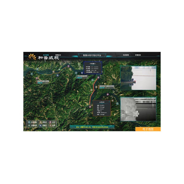
4) High-definition offline map: support offline map; support photoelectric video, water quality and water level, flow and rainfall, river inspection data based on the comprehensive situation distribution display of map; support display historical alarm information on the map and display high-risk areas by means of heat map ;
5) Photoelectric tracking: support target intrusion tracking in key areas, identification and tracking of personnel and vehicles, and photoelectric relay tracking;
6) Intelligent algorithm: support the detection of floating objects on the water surface, fishing detection, illegal sand mining detection; support the detection of personnel, vehicles and swimmers in the control area;
7) Big data analysis: support statistical analysis of photoelectric equipment and various sensor states; support statistical analysis of photoelectric, sensor, manual inspection and other alarm data; support large-screen visualization and real-time display of statistical analysis of various data.
Application scenarios:
It is widely used in the monitoring and management of rivers, lakes, reservoirs, water resources and water conservancy projects, and monitoring of urban hydrology, mountain torrent disasters, and river basin hydrological information.
Model name | SW1000 intelligent water integrated management system |
Applicable equipment | Photoelectric turntable, photoelectric cloud table, 4G water level ball, general security camera |
System performance | Not less than 1000 road equipment access, not less than 200 road equipment at the same time warning No less than 100 users are online at the same time |
Water monitoring | 1. Water shoreline: Support River, lake, reservoir and other water information management; support intersections, water intakes, sewage outlets, mining areas, reserves and other sensitive water information management; We will support the management of information on coastal areas such as market towns and villages along rivers, and the management of marking of areas where swimming is prohibited, mining is prohibited, fishing is prohibited, and so on 2. Hydrological monitoring: support water level, water quality, flow rate, rainfall and other hydrological sensor data access 3. Long-range fixed-point patrol: support automatic long-range fixed-point patrol of key river, sensitive water area and forbidden area, hidden danger identification, video evidence collection and alarm reporting 4. Mobile patrol scheduling: Support Mobile Patrol, route planning guidance, task scheduling, River Patrol Card, Danger Report, patrol personnel abnormal behavior detection 5. Multi-source warning monitoring: support hydrological threshold warning, photoelectric patrol warning, manual patrol warning; support rapid warning, photoelectric observation; support warning video capture evidence, location 6. History Warning: Support History Warning List Query, map distribution query, warning video playback, warning image review, alarm event processing detailed review; Support for historical alarm export and import, alarm event information archived download |
Video Surveillance | 1. Video Preview: support for Single Device Connection, batch connection, drag-and-drop connection; support for single device disconnect, all disconnect; support for automatic reconnect after abnormal video disconnect; support for 1/3/4/6/9/16/25 screen preview; support for video connection; support for video connection; support for video connection; support for video connection; support for video connection; support for video connection; support for video connection; support for video connection Support multi-screen position exchange display; support TV mode display; support video window function button fast operation and right-click menu operation; support video manual video, manual capture, timing task video 2. Head Control: support eight-direction head control; support zoom, focus, aperture lens control; support horizontal angle positioning, pitch angle positioning, field of view angle positioning; Support 3D click positioning, box selection zoom positioning; support mouse gesture control cloud; support equipment coordination, exclusive control, preemptive control 3. Pre-position & Cruising: Support Hardware pre-position, software pre-position, pre-position watch; support fan scan, line scan, hardware pre-position cruising, software pre-position cruising detection; Support round-the-clock mode inspection, timed task inspection 4. Remote Configuration: support photoelectric equipment remote switch, restart, cooling hot image switch, image stabilization adjustment, camera parameters remote settings; support thermal image warning threshold remote settings 5. Information superposition: real-time azimuth information, shot field of view information, bandwidth flow information, ranging information and preset position name are supported in video superposition It can display the target information such as person, vehicle and ship, and can also display the orientation information, elevation information, longitude and latitude information of the target Support AR tag intelligence information fusion 6. Condition Monitoring: supports real-time monitoring of connection status and fault status of photoelectric equipment; supports monitoring horizontal azimuth, pitching azimuth and field of view angle 7. VIDEO PLAYBACK: support local video playback, alarm video playback, disk array video playback, NVR, IPC device video playback; Video summary playback support 8. Support user view rotation 9. Support multi-monitor N * (1/3/4/9/16/25) way of video preview |
Intelligent algorithms | 1. Target recognition: support visible light, thermal imaging video on people, vehicles, ships, UAV (optional) and other target detection; support through the identification of people, vehicles and ships to enhance the accuracy of the warning 2. Special Scene Detection: support detection of floating objects on the water surface, detection of swimming in dangerous areas, detection of illegal fishing and detection of illegal sand mining 3. Target tracking: support target intrusion tracking, box tracking, identification tracking; support optoelectronic equipment hardware tracking control, back-end software algorithm scheduling tracking; support warning target temporary tracking, in the process of tracking, the focus is automatically adjusted, the target is identified by the scheduling algorithm, and the tracking state is adjusted according to the recognition result 4. Video summarization (optional) : video summarization with support of warning video; target summarization information recording of support, people, cars, boats, swimming, fishing, sand mining, floater, UAV (optional) , etc. 5. Panoramic stitching: support for visible light panoramic stitching, thermal imaging panoramic stitching; support for level 360 ° , pitch ≥50 ° seamless panoramic stitching; support for panoramic image upload and download function; Support Panorama mode monitoring display; support in the panorama to mark the current view, preset position, warning position; support through the panorama position click on the linkage photoelectric 6. Regional intrusion warning: support intrusion warning, cross-border warning; support intrusion detection personnel, vehicles, ships filtering function |
Electronic maps | 1. Two-dimensional map: support offline high-definition two-dimensional map; support electronic map, Google satellite map, sky map, vector map switch; support map distance measurement, area measurement, point line surface layer drawing; Support map drag, Zoom, zoom operation; support scale, Hawk-eye view; support offline map drag range limit; support administrative border highlight; support map different background mode display 2. Three-dimensional map (optional) : support satellite map three-dimensional rendering and display; support two-dimensional map in the local three-dimensional map transition function; Support for distance measurement, area measurement, point, line and surface rendering functions of the three-dimensional projection effect display 3. Situation Distribution: support photoelectric equipment, rivers, lakes and reservoirs, sensitive waters, forbidden areas, real-time water level information, warning information based on 2D/3D map (optional) integrated situation distribution display; Support optoelectronic device video pop-up observation and cloud mirror function scheduling; support for anti-control map optoelectronic devices 4. The height positioning technology supporting the target, the actual positioning accuracy is less than 50m 5. Support based on two-dimensional/three-dimensional map (optional) show the distribution of heat map 6. Box Search: support for map box search function; support for the search results of the classification filter query, positioning and photoelectric guided viewing |
External equipment | 1. Supports Gyro image stabilization control 2. Support Electronic compass, laser ranging data access 3. Support water quality, water level, rainfall and other types of sensor data access 4. Supports access to network broadcast devices 5. Center end supports access to SMS cat, sound and light alarm, SMS platform |
Interface Protocol | 1. RTSP, GB28181(optional) , ONVIF video protocol access, support haikang, Dahua, Yushi and other mainstream manufacturers equipment protocol access, support Huawei video platform access 2. Secondary development: support SDK secondary development; support Restful API platform docking; support to provide RTSP, GB28181(optional) , WEBRTC -LRB-optional) and other formats of video streaming 3. Support domestic mainstream manufacturer radar protocol access 4. Support the docking support of domestic operating system |