
Product introduction:
DF3000 Key Area Video Security Software (hereinafter referred to as DF3000) is independently developed by HopeVision. It is a comprehensive security platform integrating user management, video surveillance, 2D and 3D electronic maps, target recognition of people, vehicles and objects, and regional intelligent control. Starting from the actual business needs, the system combines audio and video technology, deep learning technology, network communication technology and software platform technology to build a system platform software based on optoelectronic equipment. The system has the functions of automatic detection of hidden dangers, identification of hidden dangers, precise location of hidden dangers, reporting of hidden dangers information, and tracking and processing of hidden dangers.
The system has strong industry applicability and can be applied to the security of key areas in various fields of people's livelihood, such as oil fields, chemical plants, and industrial parks. The system has a business mode of manual control, and also supports unattended intelligent inspection of key areas. The system provides users with automated and semi-automated business operation modes through the scheduling and integration of business processes, saving users' energy investment to the greatest extent. The system adopts the design concept of micro-service and modularization. Through the integration of various functions, the minimum granularity of each service module in the system is realized to ensure that the built service module has the characteristics of high cohesion and low coupling.
The system can fully support Hepu's photoelectric pan-tilt and photoelectric turntable devices, which usually have dual channels of visible light and thermal imaging, and have the function of returning the azimuth field of view angle.
Features:
1) Unattended: support the regional monitoring mode of fan scan, line scan and preset cruise scan; support day and night all-time, all-weather automatic monitoring of specific targets; support specific types of target identification, video evidence collection and alarm reporting functions;
2) Multi-level management and control: support central cluster deployment and use in multiple places; support regional multi-level joint prevention and control and multi-level alarm reporting; support coordination, exclusive, preemption and other strategic scheduling of optoelectronic equipment at all levels;
3) Intelligent inspection: supports the task of regular inspection of key locations in a 360° area; supports enabling the intelligent detection function for any key location, and can alert specific targets intruded and identified in key areas; supports different scenarios in day and night. detection mechanism;
4) Artificial intelligence algorithm: support visible light, thermal imaging video to identify people, vehicles, animals, drones and other targets algorithm; support target intrusion detection in the area, photoelectric follow-up target tracking function; support algorithm for intrusion and tracking targets identification function;
5) Accurate target positioning: Support to quickly and accurately lock the GPS coordinates of the target in the video screen with the help of DEM elevation data information;
6) Radar linkage: It supports the access of mainstream radar signals on the market, and can guide the optoelectronics through the target signals detected by the radar;
7) High-definition offline maps: support high-definition offline two-dimensional electronic maps, two-dimensional satellite maps, and three-dimensional satellite maps; support marking optoelectronic devices on the map and display the capability coverage of optoelectronic devices; The real-time data automatically updates the field of view direction; supports real-time display of target information identified by the algorithm on the map; supports the display of historical warning targets on the map and the use of heat maps to display high-risk areas.
Application scenarios:
It is widely used in the security of key areas in various fields of people's livelihood such as oil depots, chemical plants, industrial parks, etc.
Model name | DF3000 key area video security system |
Applicable equipment | Photoelectric turntable, photoelectric cloud table, electronic sentry Regular security camera |
System performance | Not less than 1000 road equipment access, not less than 200 road equipment at the same time warning No less than 100 users are online at the same time |
Area monitoring | 1. Warning Detection: support fixed-point monitoring and cruise monitoring, single equipment no less than 500 areas of moving target warning, intrusion warning, target identification warning; Support Warning Notification, sound and light warning, warning pop-up window; support SMS warning 2. Alarm linkage: support alarm linkage video, can set the duration of the linkage video; support alarm linkage capture, can be linked to capture 1 image or multiple images continuous capture 3. Target tracking: support area watch intrusion tracking, pre-position cruise intrusion tracking, box selection tracking, recognition tracking; support optoelectronic equipment hardware tracking, back-end software algorithm scheduling tracking; It supports the temporary tracking of the warning target, automatically adjusts the focus in the tracking process, the target recognition is carried out by the scheduling algorithm, and the tracking state is adjusted according to the recognition results 4. Laser linkage: support for radar target data access and real-time updating of target position information on the map; support for manual selection of targets to guide electro-optical tracking; support for automatic guided electro-optical observation to guard against targets found by radars in the area; And automatic target identification and event recording 5. Algorithm Review: support algorithm to review the correctness of warning, modify the level of warning; support the use of target recognition algorithm to automatically review the warning; support the use of trajectory tracking algorithm to automatically review the warning 6. Manual Review: To Support Manual Review of the regional information, repeated revision review results, alarm cause calibration; to support the rapid handling of alarm and reporting functions 7. False alarm area shielding: it can shield part of false alarm area by means of false alarm area, and can draw false alarm area based on photoelectric real-time video Support General Mode Virtual Police area, time-period mode virtual police area, date mode virtual police area; support thermal imaging special virtual police area, visible light special virtual police area 8. History Warning: Support History Warning List Query, map distribution query, warning video playback, warning image review, alarm event processing detailed review; Support for historical alarm export and import, alarm event information archived download |
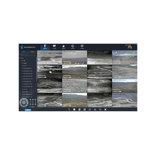
Video surveillance | 1. Video Preview: support for Single Device Connection, batch connection, drag-and-drop connection; support for single device disconnect, all disconnect; support for automatic reconnect after abnormal video disconnect; support for 1/3/4/6/9/16/25 screen preview; support for video connection; support for video connection; support for video connection; support for video connection; support for video connection; support for video connection; support for video connection; support for video connection Support multi-screen position exchange display; support TV mode display; support video window function button fast operation and right-click menu operation; support video manual video, manual capture, timing task video 2. Head Control: support eight-direction head control; support zoom, focus, aperture lens control; support horizontal angle positioning, pitch angle positioning, field of view angle positioning; Support 3D click positioning, box selection zoom positioning; support mouse gesture control cloud; support equipment coordination, exclusive control, preemptive control 3. Pre-position & Cruising: Support Hardware pre-position, software pre-position, pre-position watch; support fan scan, line scan, hardware pre-position cruising, software pre-position cruising detection; Support round-the-clock mode inspection, timed task inspection 4. Remote Configuration: support photoelectric equipment remote switch, restart, cooling hot image switch, image stabilization adjustment, camera parameters remote settings; support thermal image warning threshold remote settings 5. Information superposition: real-time azimuth information, shot field of view information, bandwidth flow information, ranging information and preset position name are supported in video superposition It can display the human, vehicle and animal target information, and can also display the orientation information, elevation information, longitude and latitude information of the target Support AR Tag Intelligence Information Fusion 6. Condition Monitoring: supports real-time monitoring of connection status and fault status of photoelectric equipment; supports monitoring horizontal azimuth, pitching azimuth and field of view angle 7. VIDEO PLAYBACK: support local video playback, alarm video playback, disk array video playback, NVR, IPC device video playback; Video summary playback support 8. Support user view rotation 9. Support multi-monitor N * (1/3/4/9/16/25) way of video preview |
Intelligent algorithms | 1. Target recognition: support visible light, thermal imaging video on people, cars, animals, UAV -LRB-optional) and other target detection; support through the identification of people, vehicles and objects to enhance the accuracy of the warning 2. Trajectory tracking: support the trajectory analysis of moving target, and combined with video display trajectory path; support the use of trajectory analysis to enhance the accuracy of the warning 3. Video summarization (optional) : video summarization with support of alarm video; target summarization information recording of support, people, cars, animals, UAV (optional) 4. Panoramic stitching: support for visible light panoramic stitching, thermal imaging panoramic stitching; support for level 360 ° , pitch ≥50 ° seamless panoramic stitching; support for panoramic image upload and download function; Support Panorama mode monitoring display; support in the panorama to mark the current view, preset position, warning position; support through the panorama position click on the linkage photoelectric 5. Regional intrusion warning: support intrusion warning, cross-border warning; support intrusion detection personnel, vehicle filtering function 6. Support the intelligent alarm function of access photoelectric equipment |
Electronic maps | 1. Two-dimensional map: support offline high-definition two-dimensional map; support electronic map, Google satellite map, sky map, vector map switch; support map distance measurement, area measurement, point line surface layer drawing; Support map drag, Zoom, zoom operation; support scale, Hawk-eye view; support offline map drag range limit; support administrative border highlight; support map different background mode display 2. Three-dimensional map (optional) : support satellite map three-dimensional rendering and display; support two-dimensional map in the local three-dimensional map transition function; Support for distance measurement, area measurement, point, line and surface rendering functions of the three-dimensional projection effect display 3. Situation Distribution: support photoelectric equipment, guard area, custom layer area, warning information based on 2D/3D map (optional) integrated situation distribution display; Support optoelectronic device video pop-up observation and cloud mirror function scheduling; support for anti-control map optoelectronic devices 4. The height positioning technology supporting the target, the actual positioning accuracy is less than 50m 5. Support for thermal maps based on 2D/3D maps (optional) showing target distribution 6. Box Search: support for map box search function; support for the search results of the classification filter query, positioning and photoelectric guided viewing |
External equipment | 1. Supports Gyro image stabilization control 2. Support Electronic compass, Laser Ranging Data Access 3. Support perimeter, electronic fence and other types of sensor data access 4. Supports access to network broadcast devices 5. Center end supports access to SMS cat, sound and Light Alarm, SMS platform |
Interface Protocol | 1. RTSP, GB28181(optional) , ONVIF video protocol access, support haikang, Dahua, Yushi and other mainstream manufacturers equipment protocol access, support Huawei video platform access 2. Secondary development: support SDK secondary development; support Restful API platform docking; support to provide RTSP, GB28181(optional) , WEBRTC -LRB-optional) and other formats of video streaming 3. Support domestic mainstream manufacturer Radar Protocol Access 4. Support the docking support of domestic operating system |