
Product introduction:
FR4000 Intelligent fire alarm software (hereinafter referred to as FR4000) is independently developed by HopeVision, and has important functions such as user management, video surveillance, 2D and 3D electronic map, fire location, fire spread analysis and forest fire resource management. Starting from the actual business requirements, the system combines video technology, hot spot detection technology, deep learning technology, network communication technology and software platform technology to build a system platform software based on optoelectronic equipment. The system has the functions of automatic detection of hidden dangers, identification of hidden dangers, precise location of hidden dangers, reporting of hidden dangers information, and tracking and processing of hidden dangers.
By digging deeply into the needs of industry users, a set of fire prevention business disposal procedures suitable for practical applications is designed, which covers suspicious heat source detection and analysis, dual-light pyrotechnic identification algorithm-assisted analysis, dynamic fire tracking, fire risk analysis and disasters Business processes for closed-loop processing such as evaluation, manual repetitive disposal decisions, etc. The system provides users with automated and semi-automated business operation modes through the scheduling and integration of business processes, saving users' energy investment to the greatest extent. The system adopts the design concept of micro-service and modularization. Through the integration of various functions, the minimum granularity of each service module in the system is realized to ensure that the built service module has the characteristics of high cohesion and low coupling.
The system can support Hepu's thermal imaging fire source detection and warning photoelectric equipment, which usually has dual channels of visible light and thermal imaging, and has the functions of hot spot detection and azimuth field of view angle return.
Features:
1) Unattended: support the fire monitoring mode of fan scan, line scan, frame scan and preset cruise scan; support setting cruise plan; support all day and night, all-weather fire monitoring and automatic fire analysis, video recording and reporting Function;
2) Multi-level management and control: support central cluster deployment and common use in multiple places; support multi-level joint prevention and control of counties, cities, and provinces; support strategy scheduling such as coordination, exclusiveness, and preemption of optoelectronic devices at all levels;
3) Precise positioning of the fire point: With the help of DEM elevation data information, the GPS coordinates of the fire point in the video screen can be quickly and accurately locked and displayed on the electronic map;
4) Dynamic fire tracking: supports the function of dynamic fire identification and tracking, and automatically identifies whether the fire is a moving fire source; supports automatic analysis of the spread speed and direction of dynamic fire in combination with meteorological data, terrain, vegetation and other information. It can analyze the spreading trend in the next half hour/1 hour, and support the calculation of fire area and post-disaster assessment;
5) Multi-technology collaborative reduction of false alarms: Supports the use of multi-dimensional technologies such as false alarm area shielding technology, continuous alarm monitoring, edge-removing sensitive false alarms and dual-light pyrotechnic identification algorithms, and composite analysis to reduce the false alarm rate of fire;
6) Artificial intelligence algorithm: support the recognition of smoke and fire in visible light video; support fire recognition in thermal imaging video; support algorithm recognition of people, vehicles, drones and other targets in visible light and thermal imaging video; Photoelectric follow-up target tracking function; support algorithm identification function for intrusion and tracking targets;
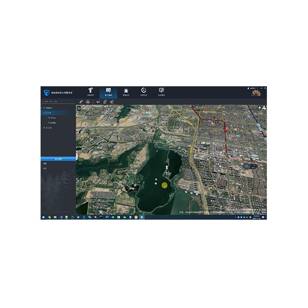
7) High-definition online/offline maps: support high-definition online/offline two-dimensional electronic maps, two-dimensional satellite maps, and three-dimensional satellite maps; support to mark optoelectronic devices on the map and display the capability coverage of optoelectronic devices; support to display the current field of view pointing And automatically update the field of view according to the real-time data monitored; support to display the latest fire point, historical fire situation on the map and display high-risk areas by means of heat map;
8) Extended peripheral access: support access to SMS cat devices, SMS gateways (China Mobile, Alibaba Cloud), and micro-meteorological devices; support access to data signals from various sensors.
Application scenarios:
Widely used in forest and grass fire prevention, tourism scenic spots, nature reserves fire prevention, straw burning ban, power transmission lines, chemical parks, oil depots, oil/gas pipeline fire prevention, environmental protection and other fire monitoring scenarios.
Model name | FR4000 intelligent fire alarm system |
Applicable equipment | Hot Warning Photoelectric Turntable, photoelectric cloud table, electronic sentry General Security Camera |
System performance | Not less than 1000 road equipment access, not less than 200 road equipment at the same time warning No less than 100 users are online at the same time |
Fire monitoring | 1. Fire Alarm: support for monitoring thermal warning information photoelectric equipment; support for warning notification, sound and light warning, warning pop-up function; support for SMS/email warning 2. Fire linkage: support alarm linkage video, can set the duration of linkage video; support alarm linkage capture, can be linkage capture 1 image or multiple images continuous capture 3. False Alarm Shield: it supports the function of blocking the hot spot alarm in specific area, drawing the false alarm area based on the photoelectric real-time position, adding the false alarm area quickly based on the alarm video and alarm picture Support General Mode false alarm area, time-period mode false alarm area, date mode false alarm area; support special thermal imaging false alarm area, visible light special false alarm area; Supports discrete alarm filtering 4. Fire Analysis: support fire location, fire system rating, dynamic fire judgment and tracking, fire risk grade analysis, fire spread speed, spread direction, fire area analysis; Support Fire Hazard Assessment 5. Fire Review: support algorithm to automatically review fire, automatically correct fire level; support manual review fire, manually determine fire level, repetitive revision review results, fire cause calibration; Support for rapid handling of alarm, reporting function 6. Historical Fire: support historical fire list query, map distribution query, fire warning video playback, alarm image review, detailed fire event handling process review; Support Historical Fire Export and import, fire event information archiving and downloading; 7. Support the addition, import and export of artificial ignition point 8. Fire resources: support the management, inquiry and search of forest fire responsibility area, contact person, protection object, disaster relief material, disaster relief team, disaster relief personnel, emergency plan, etc. |
Video surveillance | 1. Video Preview: support for Single Device Connection, batch connection, drag-and-drop connection; support for single device disconnect, all disconnect; support for automatic reconnect after abnormal video disconnect; support for 1/3/4/6/9/16/25 screen preview; support for Video Connection; support for Video Connection; support for Video Connection; support for Video Connection; support for Video Connection; support for Video Connection; support for Video Connection; support for Video Connection Support multi-screen position exchange display; support TV mode display; support video window function button fast operation and right-click menu operation; support video manual video, manual capture, Timing Task Video 2. Head Control: support eight-direction head control; support zoom, focus, aperture lens control; support horizontal angle positioning, pitch angle positioning, field of view angle positioning; Support 3D click positioning, box selection zoom positioning; support mouse gesture control cloud; support equipment coordination, exclusive control, preemptive control 3. Pre-position & Cruising: Support Hardware pre-position, software pre-position, pre-position watch; support fan scan, line scan, frame scan, hardware pre-position cruising, software pre-position cruising detection; Support round-the-clock mode inspection, Timed Task Inspection 4. Remote Configuration: support photoelectric equipment remote switch, restart, cooling hot image switch, image stabilization adjustment, camera parameters remote settings; support thermal image warning threshold remote settings 5. Information superposition: real-time azimuth information, camera field of view information, bandwidth flow information, weather information and preset position name are supported in video superposition Support overlay display algorithm recognition of smoke, fire, people, vehicles and other target information; support alarm video, alarm capture map overlay fire orientation information, elevation information, latitude and longitude information; Support AR Tag Intelligence Information Fusion 6. Condition Monitoring: supports real-time monitoring of connection status and fault status of photoelectric equipment; supports monitoring horizontal azimuth, pitching azimuth and field of view angle 7. VIDEO PLAYBACK: support local video playback, alarm video playback, disk array video playback, NVR, IPC device video playback; Video summary playback support 8. Support user view rotation 9. Support multi-monitor N * (1/3/4/9/16/25) way of video preview |
Intelligent algorithms | 1. Firework recognition: visible light support for smoke, fire target detection, thermal imaging support fire target detection; support firework recognition algorithm for automatic review of fire alarm 2. False alarm filtering: supports false alarm detection for common heat source targets such as the sun, reflections, and chimneys 3. Person-vehicle identification: support visible light, thermal imaging video of the person, vehicle target detection; support through the detection of work vehicles, construction vehicles filter fire warning 4. Video Summary (optional) : support for alarm video video abstract extraction; support for smoke, fire, people, cars, the sun and other target summary information recording 5. Panoramic stitching: support for visible light panoramic stitching, thermal imaging panoramic stitching; support for level 360 ° , pitch ≥50 ° seamless panoramic stitching; support for panoramic image upload and download function; Support Panorama mode monitoring display; support in the panorama to mark the current view, preset position, warning position; support through the panorama position click on the linkage photoelectric 6. Regional intrusion warning: support intrusion warning, cross-border warning; support intrusion detection personnel, vehicle filtering function 7. Support the intelligent alarm function of access photoelectric equipment |
Electronic maps | 1. 2D MAP: Support Online/offline high-definition 2D map; support electronic map, Google satellite map, sky map, vector map switch; Support map distance measurement, area measurement, point line surface layer drawing; support map drag, Zoom, zoom operations; support scale, Hawk-eye view; support offline map drag range limit; Supports highlighting administrative boundaries; supports different background color modes on maps 2. Three-dimensional map (optional) : support satellite map three-dimensional rendering and display; support two-dimensional map in the local three-dimensional map transition function; Support for distance measurement, area measurement, point, line and surface rendering functions of the three-dimensional projection effect display 3. Situation Distribution: support photoelectric equipment, fire resources, custom layer area, warning information based on 2D/3D map (optional) integrated situation distribution display; Support optoelectronic device video pop-up observation and cloud mirror function scheduling; support for anti-control map optoelectronic devices 4. It supports the technology of ignition elevation positioning, and the actual positioning accuracy is less than 50m 5. Support for thermal maps showing fire based on 2D/3D maps (optional) 6. Box Search: support for map box search function; support for the search results of the classification filter query, positioning and photoelectric guided viewing |
External equipment | 1. Supports Gyro image stabilization control 2. Support Electronic compass, Laser Ranging Data Access 3. Support micro-weather, all kinds of sensor data access 4. Supports access to network broadcast devices 5. Center end supports access to SMS cat, sound and Light Alarm, SMS platform |
Interface Protocol | 1. RTSP, GB28181(optional) , ONVIF video protocol access, support haikang, Dahua, Yushi and other mainstream manufacturers equipment protocol access, support Huawei video platform access 2. Secondary development: support SDK secondary development; support Restful API platform docking; support to provide RTSP, GB28181(optional) , WEBRTC -LRB-optional) and other formats of video streaming 3. Support the docking support of domestic operating system |