Details
introduction:
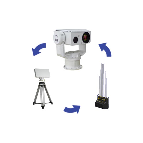
The "Guardian I" anti-UAV defense system is composed of a radar detection subsystem, an optoelectronic tracking subsystem, a radio interference countermeasure subsystem and other equipment, as well as the RGS1000 low-altitude early warning and control platform. The system uses the radar detection sub-system to complete the detection, positioning and tracking of the low-slow and small UAV targets, guides the photoelectric tracking sub-system to perform video forensics, and guides the radio interference counter-system to deal with the target. Comprehensive use of multi-spectrum detection, heterogeneous system interconnection, multi-source data fusion, intelligent analysis and decision-making and other technologies to achieve early detection, fast locking, stable tracking, accurate identification and strong countermeasures of low-altitude UAVs, and multiple detection methods complement each other , a variety of frequency band interference interception, which can effectively protect the low-altitude safety of key places all day, all time, and all dimensions.
The system is mainly equipped for public security, armed police, army, government and other users, and is often used for the prevention and control of drone targets such as prisons/detention centers, large gatherings, and public places.

Product Appearance Drawing of Radar Detection Subsystem (Reference)
The radar detection subsystem detects low, slow and small UAVs by transmitting radio waves and detecting echoes. The radar echo signals of targets in the airspace are collected by the antenna feeder system, filtered, amplified, and down-frequency processed by the radio frequency components and transmitted to the signal. processing board. The signal processing board performs signal accumulation, clutter elimination, etc., and reports the processed radar detection target angle, speed, distance and other information to the data processor and system terminal.

Photoelectric tracking subsystem product appearance diagram (reference)
The optoelectronic tracking subsystem uses visible light cameras and infrared thermal imagers to automatically track and lock low-slow and small UAV targets, and analyzes the morphological features or motion features of the targets through image acquisition and processing to achieve target detection, automatic identification, locking and tracking, and video recording. Review and boot countermeasure devices. Provide command and decision makers with intuitive real-time image information of the target. Under the guidance of the distance, azimuth, and altitude information provided by the command and control system, the drone can be found, tracked, and automatically identified. Optoelectronic equipment can also conduct autonomous search and detection of short-range low-altitude flying objects, and implement auxiliary low-altitude surveillance.

Product appearance diagram of radio interference countermeasure subsystem (reference)
The radio interference countermeasure subsystem uses radio frequency technology to interfere with the flight control channel, GNSS signal and image transmission signal of low-slow and small UAVs. UAVs entering the coverage area cannot obtain satellite positioning information. At the same time, UAVs Both the control signal and the image transmission signal to the ground controller were cut off, forcing the drone to return or land and lose the image transmission function.

RGS1000 low-altitude early warning and control platform (reference)
The RGS1000 low-altitude early warning and control platform can be connected to the radar detection subsystem, photoelectric tracking subsystem, radio countermeasure equipment and other UAV detection, identification, and countermeasure equipment at the same time. A comprehensive visual anti-UAV command and management platform that integrates functions such as linkage, decision-making and command, record and forensics, and event retrieval.
Features:
radar detection subsystem
1) The ability to monitor low-altitude, slow and small targets, flexible deployment, fully automatic, and all-weather work;
2) The three-coordinate primary radar has altimetry capability;
3) Support unattended operation, reduce the difficulty of work, and avoid the interference of electromagnetic radiation to operators.
Photoelectric tracking subsystem
1) It can carry a long-focus visible light camera, a large-diameter infrared thermal imager, and optional sensing modules such as laser illuminator, laser ranging, positioning and navigation, digital compass, etc., to achieve ultra-long-distance target observation;
2) Fast turning speed: the turning speed can reach 80°/s, the acceleration can reach 100°/s2, the start and stop are fast, and the operation is smooth, which is helpful for capturing and tracking fast-moving targets;
3) Wide coverage: the azimuth rotation range is 0°~360°, and the pitch rotation range is -90°~+90°, realizing no dead angle detection and full-dimensional coverage;
4) High control accuracy: using a precision angle encoder with a high-precision closed-loop servo control system, the positioning accuracy can reach 0.02°, and the high-performance image processing unit is equipped with a high-precision focus control mechanism to achieve precise automatic focusing;
5) The automatic tracking module designed with a variety of advanced target acquisition algorithms and tracking algorithms, supplemented by high-precision servo control, ensures stable tracking of the target during fast flight and direction change.
Radio Interference Countermeasure Subsystem
1) It has the ability to effectively interfere with the signals of general-purpose UAVs and model-modified UAVs, causing them to return or make forced landings;
2) The frequency range of navigation signal processing includes: GPS, GLONASS, Beidou, Galileo and other navigation systems;
3) The working mode of data link processing and navigation signal processing can be freely selected or set by the user.
Application scenarios:
It is mainly used for low-altitude security protection in key places such as bases, airports, prisons, nuclear, biological and chemical industries, conference centers, office buildings, oil fields, and oil depots.